
Delaware & Hudson Canal Interpretive Center
16 Bova Road, Summitville, NY 12781
(845) 888-5040
Free Admission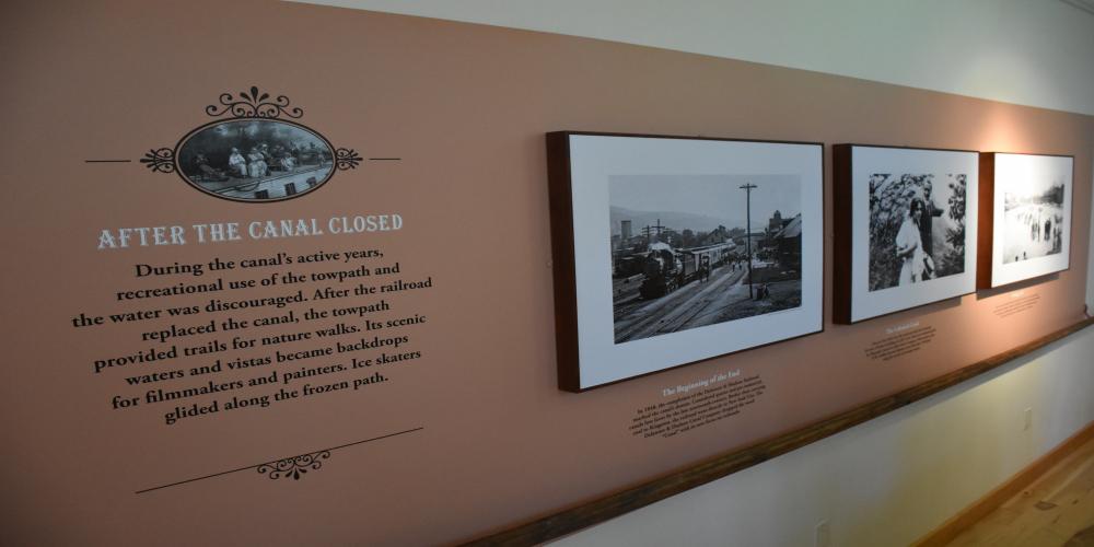
2024 Interpretive Center Hours:
Memorial Day Weekend
Saturday: 10 a.m. - 5 p.m.
Sunday: 10 a.m. - 5 p.m.
Monday: 12:00 p.m. - 5 p.m.
June 14th through Labor Day Weekend:
Fridays and Saturdays: 10 a.m. – 5 p.m.
Sundays: 12 p.m. – 5 p.m.
Labor Day: 10 a.m. - 5 p.m.
Trails and grounds open year-round: 8 am - Dusk
About the Interpretive Center:
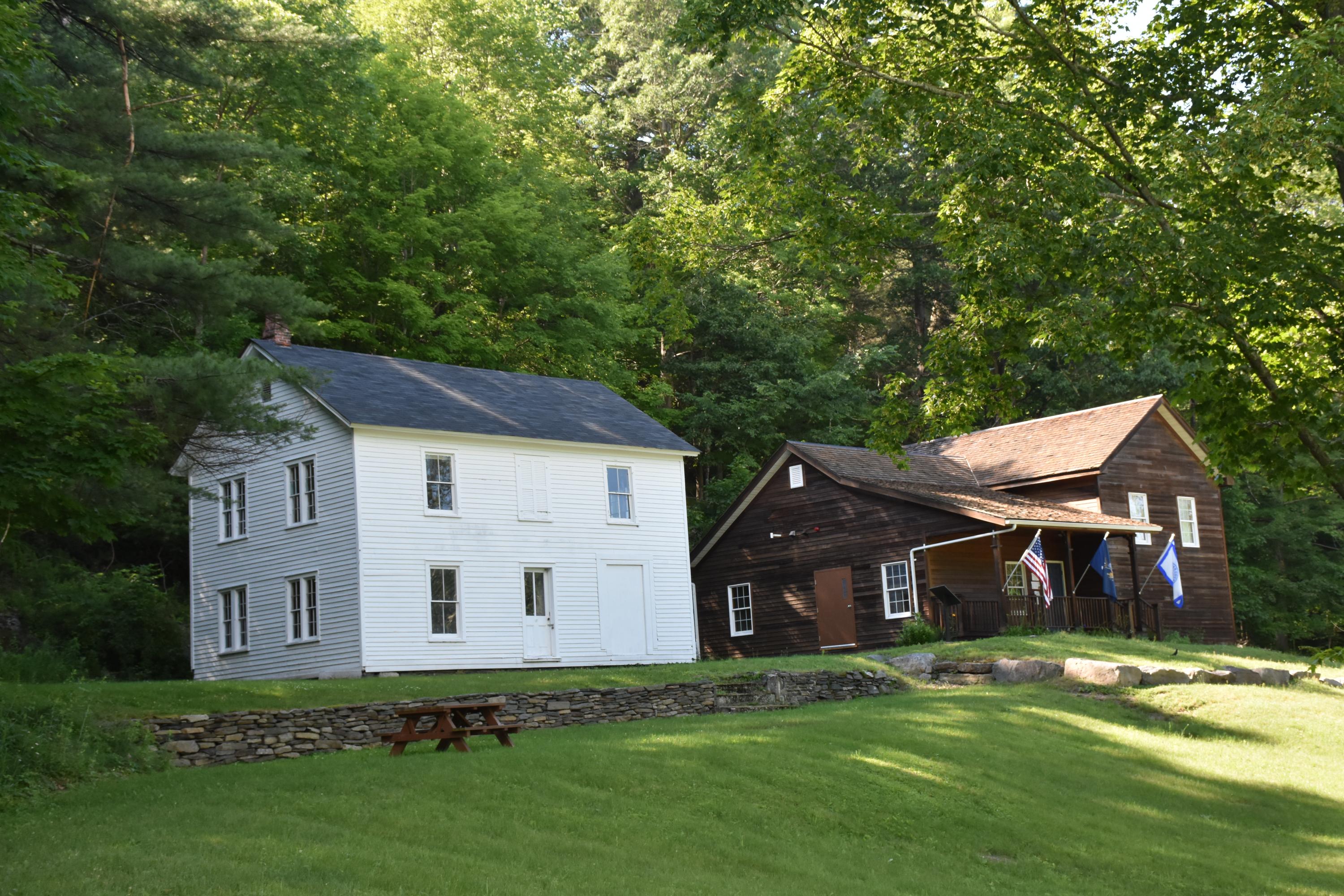
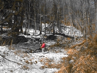
There are two buildings located in the park as shown in the above picture. The white building on the left, built in the 1850s, was typical of the canal-side homes of that time. (More about this structure later on.)
The brown building on the right is our modern Interpretive Center, which opened in 2011. Interpretive centers are informal educational venues, designed to give the public a chance to learn about the natural or cultural heritage of a site.
Despite very little physical evidence today, the Delaware and Hudson (D&H) Canal was the preeminent feature found along the southern edges of Sullivan County for most of the 19th century. The Interpretive Center guides us through that sometimes forgotten dynamic period of growth, housing a variety of exhibits and displays that tell the epic story of how coal deposits in northeastern Pennsylvania played a major role in supplying the energy needs of a growing country in the mid-1800s.
Coal mined in Pennsylvania’s Moosic Mountains was transported by an innovative gravity railroad to Honesdale, Pennsylvania and then by canal boats to Kingston, NY. The 108-mile-long canal (oddly by chance) featured 108 locks along the way. The entire canal was built by hand in just 3 years.
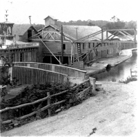
The Center takes the visitor on a journey through each phase of the canal’s construction and its 70 years of operation. Photographs document the terrible social impact the canal had on many of its employees, as well as the enormous contribution the project made to the region’s industrial development. The canal spurred the expansion of the tannery and bluestone quarrying industries. Many villages and hamlets sprung up as activities increased, putting the unlikely names of “port” on remote hamlets far removed from the water bodies one normally associates with ports.
Perhaps the single greatest feat of engineering accomplished by the canal company was the Roebling Aqueduct built in Minisink Ford, near Barryville, NY, spanning the Delaware River. To avoid conflict (and actual collisions) with the lumbermen who floated their product down the Delaware and into the path of coal-filled canal boats, the D&H Company and Brooklyn Bridge designer John Roebling built a water-filled channel suspended over the river. Roebling’s innovative use of the wire cable was instrumental in his design scheme for this project. Canal boats then navigated through these narrow channels with much greater ease and avoided the many challenges (and dangers) endured by earlier surface river crossings.
This aqueduct was one of four constructed by the canal and the only one still in use today. It was converted into a roadway when the canal closed in 1898 and is the oldest wire suspension bridge in the United States. The other three aqueducts were dismantled over time, but remnants of these vital links in the canal’s route can still be seen today. A diorama (a small-scale, glass-encased replica) of this structure built by the Smithsonian Institution and on loan from the National Park Service is on display at our center and never fails to draw the attention of our visitors.
Our center also houses a few original artifacts from the canal, photographs, paintings, documents, postcards, numerous maps, and other canal-related materials. Our bookstore includes a nice selection of both popular books on the canal as well as some technical texts for the more avid canal enthusiasts.
Now back to the old white building on the left from the above photograph. This was the home of the Boothroyd family. They operated a prosperous boatyard located on the northern side of the property. The house features a hall-in-parlor interior and a root cellar.
The exterior of this family homestead has been maintained to keep the building stable, but the interior has been frozen in time, hoping for some future restoration. It is closed to the public, but visitors are encouraged to peek in the windows. The remnants of the boatyard just a few steps away are remarkably well preserved and ready to spark the visitor’s curiosity.
These structures will also serve to test the visitor’s ability to piece together how the rather complicated lock system actually worked, with its many components. To lessen the challenge and to solve some of the mystery, a series of information display boards dot the path and tell a good part of the story. The bookstore’s offerings can fill in the rest of the story for aspiring local historians.
The New York State portion of the Delaware and Hudson Canal essentially parallels Route 209 from Port Jervis to Kingston. Many who live on or near the original path of the canal or those who regularly drive along this busy highway can be forgiven for not knowing much about what existed along this corridor more than a century ago. Only a few sections of the canal are visible from the road and may not be recognized as a canal.
Our visitors at the center tell us a similar story after stopping by the center:
“I had no idea this place was even here.”
“I can’t believe they actually built a gravity railroad and a 100-mile canal - by hand in 3 years.”
History buffs seem to find us with ease and come by to both share their expertise and add a few new facts to their body of knowledge. The general public, however, is frequently surprised to find this hidden gem along an otherwise lonely stretch of Route 209 midway between Wurtsboro and Ellenville.
Whether you are a fanatic canal enthusiast or simply wonder why there are remnants of fancy stone walls in strange places along Route 209, this Center will either solve some mysteries or fill in a few gaps about what folks were up to in our area starting in the 1820s.
________________________________________________________________________________________________________
Linear Park Walking Trails
Step Back in Time
This linear park consists of 45 acres and approximately 3½ miles of trail situated along the historic D&H Canal. Remains of the original locks, drydock & waste weirs are visible from the towpath trail. Interpretive signs are located in the park to assist the visitor identify the various canal structures. Three accesses are open at this time, two are located off Route 209. Hornbeck's basin access is located ½ mile north of Wurtsboro; the Bova Road access is located 4½ miles north of Wurtsboro between the Hamlets of Summitville and Phillipsport. The trail is ideal for hikers, bikers, cross-country skiing, snowshoeing, and nature watching. Picnic tables and grills along with porta-johns are available at both accesses.
Due to the linear nature of this park users are asked to respect the rights of adjacent landowners.
The Park itself is open year-round from 8 a.m.-dusk.
Canal History 1828 - 1898
As a result of the war of 1812 Americans were faced with an energy shortage due to the blockade of shipments of soft (bituminous) coal from England. Designed as a system of transportation between the coal fields of Pennsylvania and the ports of New York along the Hudson River, the Delaware and Hudson Canal was one of many towpath canals constructed in the early years of the nineteenth century. The coal passed over a gravity railroad to haul coal from the mines to the canal terminus at Honesdale, PA. From its opening in 1828 to its demise in 1898, the D&H Canal transported millions of tons of anthracite coal to the industrial and domestic furnaces of New York City, New England, and the river towns located along the Hudson River.
This great engineering feat was the first private enterprise project in the United States to cost more than a million dollars to build. The project was first visualized by Maurice and William Wurts (the Village of Wurtsboro was named in their honor) and financed through the influence of Philip Hone (Honesdale named after him), the Mayor of New York.
The canal was 108 miles long (Honesdale, PA to Kingston, NY) and contained 108 locks, 22 aqueducts, 136 bridges, 22 reservoirs, 16 dams and 14 feeders.
Park History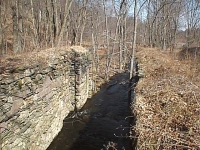
The quest to develop a park began in 1969, when the County on advice from the Sullivan County Park and Recreation Commission acquired 4 acres of property that consisted of the canal, towpath and Locks 42, 43, and 44. In 1986, Orange and Rockland Utilities generously donated 43 acres of canal and towpath. In 1988 the county was awarded a $334,750 NYS grant to purchase additional land and develop a linear park. In 1999, the County was awarded a $670,000 TEA-21 grant to further improve the park. Since its initial purchase in 1969, the County has acquired over 83 acres of parkland, 5 locks, a dry dock and has developed approximately 3 1/2 miles of canal trail, interpretive displays, trail heads, picnic areas, and parking areas.
Park Information
Sullivan County's D&H Canal Linear Park is operated and maintained by the Sullivan County Department of Parks, Recreation and Beautification. The park is open year round from dawn to dusk. The linear park is located adjacent to the Route 209 corridor in the Town of Mamakating, Sullivan County. Access to the towpath trail can be made from several points located along the trail between the Village of Wurtsboro and the Hamlet of Phillipsport (see location map). The trail is intended to accommodate a variety of users, including hikers, walkers, nature enthusiasts, bicyclists, joggers, cross country skiers and snowshoeing (motorized vehicles and horses are prohibited).
It is important to extend courtesy to all trail users and respect their rights. In order to avoid conflicts, trail protocol dictates that bicyclists yield the right of way to all trail users.
Please help us manage this park for the enjoyment of all our visitors by observing the following rules, regulations and safety tips:
Rules, Regulations and Safety Tips
|
Flora and Fauna
 The area surrounding the linear park is primarily tree covered with a predominance of deciduous tree species; the major species varying with soil type. In addition, there is a variety of understory and ground cover which adds to the 'wildness' of the forest. The northern hardwoods found in this area include sugar maple, American beech, cherry, apple, white oak, sycamore, shag bark hickory, ashes, white birch, walnut, oak, willow, tulip trees, and dogwood. Other trees found in this area are coniferous and include white pine and hemlock. The ground cover consists of a myriad of species of wildflowers, jewelweed, ferns, berries, milkweed, and such vine plants as poison ivy and grapevines.
The area along the D&H canal is the homeland for a myriad of animals, from the underfoot millipede to the overhead red-tailed hawk. The wet, lower elevations abound with those animals whose lifestyle requires an abundance of moisture. These include the freshwater clam, stonefly, mudpuppy, brown and brook trout, painted turtle, great blue heron, along with waterfowl and beaver.
As the elevation rises along the wetlands an evergreen forest dominates the landscape. The fauna of this habitat include species adapted to life around wetlands, but not necessarily in it. Inhabitants of this region include fireflies, black snakes, re-winged blackbirds, raccoon and gray fox. On higher elevations overlooking the Canal wildlife species are found which live in the deciduous forest zone. This group includes the eastern tent caterpillar, garter snake, upland birds such as ruffed grouse and wild turkey, along with song birds and raptors. Larger mammals are also residents of this zone. Among these species are the possum, weasel, red fox, white-tailed deer and an occasional coyote.
With the exception of the maintained tow path much of the canal and other canal era development has been moving back to a more natural state after a hundred years since canal abandonment.
Where the canal followed the bed of a stream the water is likely to be much like it was before the canal was dug, cold and clear with a gravelly bottom, just the conditions for trout, whether it's browns, rainbow or native brook trout. Sections running through swamps have silted in and are too warm for trout but support bullheads, chain pickerel, pumpkinseed and suckers. Look for trees that beaver have felled or their stick dams, but you are more likely to see a musk rat swimming or feeding on vegetation along the shore then the nocturnal beaver.
Plants along the canal vary depending on soil drainage. On wet sites, like the banks of the D & H Canal, white barked sycamores, speckled alder, and red maples trees can be found. In wetlands where it is wet most of the time, red maple is the most common species. White ash and swamp white oak are also present. Beneath these trees is a shrub layer of spice bush, highbush blueberry, swamp azalia and the holly winterberry. On dryer, but still moist sites, the evergreen white pine has seeded in on abandoned fields. Red oak, white oak, black gum, hemlock and sassafras can also be found.
As the weather warms and the ice and snow of winter begin to melt exposing the icy water of boggy areas near the canal, the red spotted newt can be seen swimming or resting on submerged vegetation. Soon they find their way to secluded pools and begin depositing clusters of jelly like egg masses among the tussock sedges. After several weeks the aquatic larvae emerge and spend up to seven years on land. This is the brightly colored red eft seen in spring and summer, especially on wet or damp days. Don't touch, their skin secretions are very irritating. This is the most common, but only one of more than a dozen species that live in and along the canal. During the warm months, painted turtles and water snakes can be seen sharing sunny spots on fallen trees.
On the tow path the white petaled blood root, spring beauties, and various violets can be found blooming in early spring. Just off the tow path on damp sites the yellow flowered trout lily with it's splotchy leaves can also be found.
In the middle of summer orange flowered Canada lilies and pink swamp rose begin blooming on the berm. In the late fall, the red berries of the spice bush and winterberry are the last color of the season and are soon gone as the last of the song birds pass through on there way south.